Horseshoe Bend
DRAFT DRAFT DRAFT All the different days/regions we explored in Page Arizona (August 27, 28, 29, 30, 31, September 1 and 2) can be found in the Picture Album #62, link found in each paragraph below.
We arrived in Page Arizona in the late afternoon, and managed to set up camp and have enough time to jump back in the car and head to Horseshoe Bend at the perfect time: Sunset. It was beautiful. Kayakers down at the water’s edge looked so tiny! We hope to do a water trip on the Colorado River here to see the Bend from a different perspective. The Bend is shortly after the Glen Canyon Dam which holds back the reservoir of Lake Powell.
………………………………………………………………………………………………………………………………………
.
Antelope Canyon
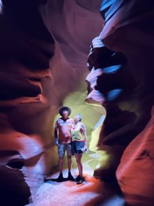
Antelope Canyon is on Navajo lands, so you must book a Navajo Indian Tour Guide to see this magnificent slot canyon. The interesting thing about this canyon is it’s ever-changing landscape, all shaped according to the waters that flow through here. Just two years ago, the floor of the canyon was about 20 feet higher than today! Flash floods constantly carve out new corners to peek around. The canyon has two areas, an Upper section and a lower section. We toured the Upper Canyon, which has a shape like an “A”, meaning the floor is wider than the top, allowing sunbeams to find their way in to the slot, while the Lower canyon is the exact opposite in the shape of a “V”. The actual tour began at their office location in downtown Page, so it is there where we hopped on a 15-person shuttle van equipped with super sized cold A/C and 4-wheel drive super-sized tires. Drove about 10 miles outside of town onto a gravel road and then down into the actual wash itself! That’s when the 4-wheel drive was needed, and was so much fun in and of itself! This was obviously not the first time this Navajo driver navigated the sometimes sandy, sometimes mushy river/wash, evidenced by his one hand on the wheel and the other holding a thermos of chilled water. The tour was not cheap, but so well worth it and I highly recommend it!
………………………………………………………………………………………………………………………………………
West Page (Wahweap Marina, Lone Rock Beach, Glen Canyon Dam, Lake Powell Boat Ride
* Wahweap Marina (also known as Lake Powell Resorts and Marina). Boat ramps closed everywhere; no boats can launch anymore because the ramp’s end is now about 40 feet above the water line!
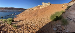
* Lone Rock Beach – this is (or was) a popular boondocking site for campers. Not so much these days due to the low water levels exposing new (and sandier) lakebed. The loose gravel and hard-to-tell dirt roads were kind of sketchy. Driving Lois down here was a bit unnerving, and I can’t imagine driving a rig down! There was one lone Boon-docker (truck and trailer rig) around, and only a few more day use folks here. Sad to see that the water has receded so far down that there is no water nowadays around the rock. YouTube videos we watched from 2020 and earlier had boats and jet-skiers driving around the rock, and boogie boards and SUPs at the water line just yards away from their campers – not so anymore sadly. 4-wheel drive is recommended.
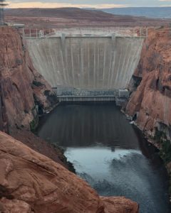
* Glen Canyon Dam – Carl Hayden Visitor Center is located right at the dam as well as the ——— bridge.
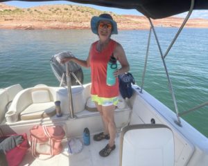
* Lake Powell Boat Ride –
………………………………………………………………………………………………………………………………………………
East Page (Antelope Point Marina, town pics, scenic drives and overlooks
Next up on our exploration of Page area was Antelope Point Marina, the newer of the two marinas in the area.
Hikes in this area included ………
………………………………………………………………………………………………………………………………………………