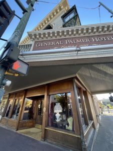

The town of Durango
Durango Colorado – beautiful place. Last time I was here was back in the late 70s as a teenager, doing a 2-week road trip out West. The two historical hotels are still here as I remembered; the Strater Hotel (which we stayed in for one night), and the General Palmer Hotel. Still just as preserved as it was back then with ‘Wild West’ decor and saloons. And of course the Train Station! Main Street has changed somewhat, lots of alfesco dining and cool shops to stroll around. Check out the picture above at the closed hunting store with what looks like a real dog in the window display – jokes on us – it IS a real live dog! He had such sweet eyes and took his job quite seriously, looking regal with his green bandana and stayed in character by not moving/interacting with people looking at him. How on earth did the owners train him to do that? and the store was closed, where are the owners? Do they leave him there all nigh? So many questions. All I can say though is “good boi”.
Take Note: there are 4 different picture album links in this post (#69, 70, 71, and 72).
Pics around town in Durango (Album #69)
………………………………………………………………………………………………………………………………………
.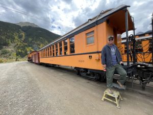
Narrow Gauge Railroad – Durango to Silverton Train
This narrow gauge railroad was built in nine short months back in 1882 and has been taking passengers on excursions ever since! It is truly a spectacular experience. They were currently running two trains every day, one steam and one diesel. We rode the diesel train in the coach immediately behind the engine. Not our first choice of seats (we actually wanted to ride the steam train and indulge in the rear luxury caboose), but with just one day planning we took what was available. They pretty much sell out everyday, and over the course of one years time they carry close to 220,000 people!
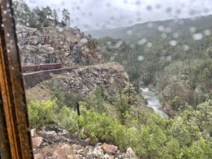
Starting off in Durango in the morning, it’s a three hour ride to Silverton. We then had 2 hours in Silverton to stretch our legs, grab lunch at Natalia’s which originally was the 1883 Welcome Saloon, and check out the gift shops lining the town’s dirt roads. Hopping back on board we got to travel three more hours back to Durango. The train stopped several times to pick up backcountry hikers from the Needles region and other small ‘stations’.
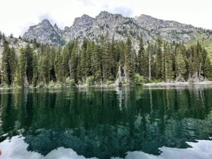
For the majority of the way, the rails follow the Animas River. We got to see the water at eye/ground level, and from a bird’s eye view when the rails were hugging the cliffside 400 feet up the side of the mountain.
Once back in Durango, we had time to quickly browse the 12,000 square foot Railroad Museum – highly recommended to visit it if you have the time; they feature many train-set dioramas, and many treasured artifacts donated by local families.
Durango-Silverton Train pics (album #70)
………………………………………………………………………………………………………………………………………
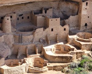
Mesa Verde National Park
Mesa Verde National Park was one that neither Jim or I knew much about. We knew of course it was the home to Cliff Dwellings, but not much else. What a treat this Park was to spend a full enjoyable day here. The scenic road inside the Park was fun to drive and offered up so many breathtaking vistas. The gentle but constant switchbacks take you through a tunnel, leading to many Overlooks, and after 20 miles that takes two hours, ends at the the Cliff Palace dwelling site at over 7,000 feet of elevation.
A nice surprise on the drive out was seeing a wild horse. We wouldn’t have seen him but for the three deer standing on high alert at the edge of the road, not looking at us, but intently checking out the far side of the road. We followed their stares and there he was, the blackest of black coats mimicking the color of the many regal Ravens there too.
An interesting fact about this National Park is that it is the only one established to preserve the archeological heritage of the Ancestral Pueblo people – there are over 4,500 archeological sites and 600 of those are cliff dwellings. You seem them everywhere you look when you look hard enough at the canyon walls.
Mesa Verde NP pics (album 71)..
…………………………………………………………………………………………………………………………………………….
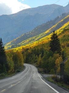
Million Dollar Highway
Yes, it was white knuckle driving! Yes, at 10,000 feet elevation the trees were showing splendid fall colors! Yes, I’d do it again in a heartbeat! Drove from Durango through Silverton (traveling through many of the same canyons carved by the Animas River) to Ouray Colorado. Had hoped to take in a hot spring in Ouray, but daylight was fast upon us, so we skipped that. However, we found that the timing upon approaching Durango afforded us a second chance at a hot spring soak at the Durango Hot Springs Resort.
Million Dollar Hwy to Ouray (album #72)
………………………………………………………………………………………………………………………………………………
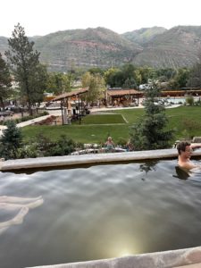
Durango Hot Springs Resort & Spa
Looking online while driving southward towards the end of our Million $ Drive, we were delighted to discover available tickets were still open for the Last Call Soak time. 7:00 PM to 9:00 PM. Perfect sunset relaxation. Mineral rich hot springs infused with oxygen-rich nano bubbles in its waters, 16 different soaking pools of various sizes and temperatures were nice to bounce around. We found a perfect 106 degree water one perched up high to overlook the center lawn and listen to the live music. It was a great evening to meet and chat amongst what was mostly locals, including a group of late-20-something professionals enjoying a hometown reunion. Growing up in Durango, they left town for better opportunities, but most all of them had plans to return to the area and plant their own family roots back in their treasured hometown. They were so warm and welcoming – great town ambassadors!
………………………………………………………………………………………………………………………………………………