The town of Torrey is only 10 miles away from Capitol Reef National Park. Hwy 24 is a spectacular drive. Although there was road construction with one-lane traffic going on causing 15 minute delays here and there, we couldn’t have been in a more scenic spot to just sit and soak in the sights of the huge red cliffs surrounding us. We spent 3 nights here which was the perfect amount of time to explore Capitol Reef for two full days. We will be back to this Park in the future.
Capitol Reef Park has been hands-down the favorite of the Mighty 5 thus far for both Jim and I. It is jaw-dropping to be up close and personal amongst the towering cliffs. A wrinkle in the Earth – a vibrant palette of color spills across the landscape before you. The hues are constantly changing, altered by the play of light against the towering cliffs, massive domes, arches, bridges, and twisting canyons. Over millions of years geologic forces shaped, lifted, and folded the earth, creating this rugged, remote area known as the Waterpocket Fold. Where did the Park get it’s name? Two features: the first being ‘Capitol Dome’, a sandstone mountain, blond in color, resembles the U.S. Capitol. And second, for the 100- mile Waterpocket Fold, which is a wrinkle that barred early travelers like a barrier reef.
* Fruita area: Apple and Cherry Pies, Yum! Capitol Reef maintains one of the largest groups of historic orchards in the National Park Service. With about 2,000 trees, fruits include apple, peach, pear, apricot, cherry and plum. Flowering typically occurs from March into May, and harvest generally occurs June through October. Fruit is free to sample while in the orchards; a small fee is charged for fruit taken out of the orchards. Although the harvest season this year was already over, we did however get to purchase some fresh-baked pies at the historic Gifford House and enjoyed them along with ice cream right beside the Fremont River. Lots of deer live here in this area and we saw many of them including spotted fawns with their moms. Pictured above is one of the sweet horses that are stabled nearby. Close to this too is the Fruita Campground which we looked into camping here, but with the temperatures being so high (in the high 90’s), we thought it best to camp at a private RV park with water and electricity to keep the AC running for Darcy. Not only was that a good decision for that factor alone, but they had Loop B closed off due to recent mountain lion activity!
* Petroglyphs: these panels are conveniently located right off the main Hwy 24; no hiking needed to pull over and park and walk the boardwalk right up to them. Very interesting! There are more carvings deep into the Park, but require backcountry long hikes to get to them which we did not do.
* The 7-8 mile long Paved Scenic Drive is a narrow but stunning drive. Quite intimidating at first, with it’s many twists and blind curves, and the many ‘washes’ that the road simply dips into and goes over. I can’t imagine being out here when it’s raining and have to cross over/ drive right through the wet washes. Thankfully, the pavement was dry so no worries there. However, there are two spur roads off the Scenic Drive that are not paved and enter into Canyons. On the first day of exploration, we wimped out on taking Lois deep into these roads, as can’t miss warning signs are posted at the entrances demanding that drivers have a healthy respect for them AND the weather. The third gravel road was definitely one for us to stay away from since it requires you have a high clearance four-wheel drive vehicle.
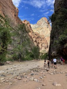
* After speaking with a Ranger at the Visitor Center on the second day, we felt a little more comfortable to consider driving the gravel roads. First up, the Capitol Gorge dirt road found at the very end of the pavement’s end. It’s two miles in length, and at the end of it you can get out on foot and hike an additional mile into the Canyon, which we did. However – a storm (really just an isolated rain cloud) was approaching, so it was enough to keep our eyes peeled and hearts a racing! Because this location was exactly where a Flash Flood occurred back in June that swept 10 or so cars down the wash, leaving some folks stranded to be rescued by helicopter. There’s a YouTube vid of someone’s first-hand experience with this particular Flash Flood. Watch it at the link
* After speaking with a Ranger at the Visitor Center on the second day, we felt a little more comfortable to consider driving the gravel roads. First up, the Capitol Gorge dirt road found at the very end of the pavement’s end. It’s two miles in length, and at the end of it you can get out on foot and hike an additional mile into the Canyon, which we did. However – a storm (really just an isolated rain cloud) was approaching, so it was enough to keep our eyes peeled and hearts a racing! Because this location was exactly where a Flash Flood occurred back in June that swept 10 or so cars down the wash, leaving some folks stranded to be rescued by helicopter. There’s a YouTube vid of someone’s first-hand experience with this particular Flash Flood. Watch it at the link
https://www.youtube.com/watch?v=FJOpZF_4b-w&t=698s&ab_channel=Owensuptosomething
* Once the Gorge was under our belts, the rain cloud had moved onwards never really releasing any rain near us. So, up next was the second exhilarating expedition into the 1.3 mile Grand Wash dirt road and hike an additional 2 miles into the Narrows. So beautiful.
————–
