Lake Tahoe – NV and CA 


Traveled from Reno down to the southern end and went around the rim counter-clockwise. First up, a very majestic view was upon us via the Heavenly Mountain Gondola ride.  The Gondola travels 2.4 miles up the mountain up to 9,123 feet to a spectacular Observation Deck. From here, we opted to hike Martin’s Trail which was a surprising highlight. I wish this blog could feature a ‘Smell-O-Rama’ button, because the air was crystal clean and smelled so good due to the Jeffrey and Ponderosa pines. Up at the very top is the Tamarack Lodge, a cool mountain roller coaster, and zip lines; quite busy in the summer even though it’s first and foremost a ski village.  Fun photo spot: the Nevada/California state line sign.
——————
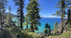
Moving onwards from South Tahoe, we intended to stop off at Emerald State Park, specifically to hike to the Vikingsholm Castle, but the parking lot was full with many cars ahead of us waiting for a spot to open up. Disappointed, we traveled on to D.L.Bliss State Park and took the Rubicon Trail down to the Cowlee Bay Beach. The colors of the alpine waters is beautiful and rivals the hues of the Caribbean. We stayed here on the beach for a while, dipping our feet into the chilly water, and playing on the rocks. A group of college guys were having fun just down from the beach on a large outcropping of rocks, hilariously clapping their hands and barking like seals at the moored sailboats nearby.
——————
We then continued our counter-clockwise rim drive and drove through the charming towns, all each unique in their own way. Finally, at the top of the circle in Incline Village, we took Hwy 431 through the beautiful Humboldt-Toiyabe Forest, briefly stopping at Mt. Rose to soak in one final and magnificent view of Lake Tahoe.  Funny moment: on our final turnout stop, we spotted our hubcap rolling off in front of the car. That’s twice now that it has fallen off and twice now that we saw it in time to recover it! It must have nine lives. LOL.
————–

Lake Tahoe Profile

Imagine how much water a lake this size and depth can hold. It’s capacity is rivaled in the U.S. only by the Great Lakes. There is enough water in Lake Tahoe to supply everyone in the U.S. with 50 gallons of water per day for 5 years!
Color can tell you a lot about a lake. Lake Tahoe is one of the purest large lakes in the U.S. – the primary reason for its iconic blue tint. Pure water absorbs light with longer wavelengths, such as red and green, while shorter wave-length violet and blue light gets scattered and reflected back to our eyes. 
If you were to empty Lake Tahoe, its 40 trillion gallons could fill a kiddie pool the size of California!
Lake Depth: almost 1/3 mile deep at 1,645 feet deep!
——————-


Reno, NV 


The Biggest Little City in the World. 
——————
Reno, NV: gateway to Lake Tahoe. We stayed in Reno for three nights, mainly to see Lake Tahoe, which we weren’t sure we were actually going to make it there due to wildfires. Yet we did! Lake Tahoe itself was a full day trip and will be discussed on next post. This post I’ll share all about the town of Reno itself.
——————
We arrived in Reno in early afternoon, in time to do a little scouting before the sun went down. Still on Pacific Time, but moving eastward we’ve noticed the sunsets are arriving earlier in the day and that is a bummer. We’ve gotten used to having a long day of daylight and the many opportunities to stay out and about before dinner. We jumped in the car after setting up camp at the Shamrock RV Park (a nice campground that we’d visit again. In fact, there’s been very few campgrounds that we’ve given the thumbs down to, or at least say we’d pick another place). Headed straight for downtown and took a nice stroll on the Reno Riverwalk. Similar to Columbus boasting the Chattahoochee River, the Truckee River meanders through town, with Class 2, 3, and even 4 rapids in certain areas. Smack downtown, the river calms a bit and welcomes kayakers and swimmers. I walked in the water myself up to my knees to cool off a bit which did the trick; the water was cool and refreshing, clean too.  There are several art installations form previous Burning Man events that have made their permanent home here on the river bank. A welcome sight to see the “BELEIVE” sculpture here, which helped take the sting out of being soooooo close to Burning Man happening in a few weeks. We visited the Black Rock Desert Playa back in 2013 – hopefully next year we can make it back “home”, which would also be a 10 year reunion. Remembering our poses with the sculpture back on the Playa, we had fun re-creating them.     
————-
Casinos aren’t much of an excitement for either of us, but of course one mustn’t miss visiting several while in town. We found the iconic “Biggest Little City in the World” sign, and strolled into the Casino strip that is Circus Circus, The Silver Gate, and the El Dorado. Although casinos are known for cheap steak dinners, neither of these three offered ‘cheap’ meals, so we decided to find an alternative Mom and Pop restaurant. By chance, we managed to find “The Original Mel’s Diner” located in the historic Sands Hotel/Casino. Fun place! We were transported back in time to the days of tail-fin cars, drive-ins, and actual jukeboxes. Sitting down at the table, we had to play a tune or two. In honor of the recently announced theme of “Disco Daze” for the upcoming Hulaween Fest, we chose appropriate 70’s disco. Jim enjoyed Steak and eggs.
————–
The next day we spent the entire day at Lake Tahoe (next Blog post).
—————
Following that, our final day in Reno was back visiting downtown. Because of Reno’s close proximity to Burning Man there is a plethora of vintage clothing stores where one can find cool and kooky outfits for the desert. I had to swing by a few; thank you “The Melting Pot Emporium” – I found a few items, namely some disco-themed apparel for Hulaween.
Afterwards, it was Jim’s turn to choose an attraction. We visited the National Automobile Museum. Our history museum opened in 1989, it was reported to have set the standard for automobile museums around the world. Since then, it has received many accolades and today it is recognized as one of 10 Best Automobile Museums in the U.S.
The idea for this Museum developed following the death Bill Harrah and the museum still exists today thanks to a persuasive public and the generosity of many.
Bill Harrah was a prominent gaming pioneer who founded Harrah’s Hotels and Casinos and the former Harrah’s Automobile Collection. He assembled the largest and most historically significant collection in the world that reached approximately 1,400 vehicles. His legacy lives on at the National Automobile Museum (The Harrah Collection).

Enjoyed lunch on this day at another local establishment (The Thai Corner Cafe), it was delicious.


California, NE corner

Pic Album #51 – Standish, CA


Just a Stop-Over

Standish, California. Never heard of it? Neither did we, but it was a good stop-over point on the map when leaving Oregon destined for Lake Tahoe, Death Valley, then to Yosemite.

Turned out the 200+ mile drive from Chiloquin, OR took us down a serendipitous scenic drive on Hwy 139 and beyond to Hwy 395.

Soo close, but not close enough to do a swing by to the Lassen Volcanic National Park. We soaked in plenty of scenery though, driving through the Modoc National Forest, the Modoc National Wildlife Reserve, and Lassen County. 

Days End RV Park

This was a Good Sam Campground located in Standish (population 779). We weren’t expecting much of the place, because all we had seen was remote, dry, wilderness/desert. In fact, the large Honey Lake nearby appeared to be totally dry.

But what a pleasant surprise; an oasis in the desert! The campground host was super friendly and laid-back, ala Cali-style.  The grounds were well-maintained, and gardens of blooming flowers were throughout. Perfect. A bit of shade at the site was welcome in the near 100-degree heat.

The weather here was a bit strange. 100 degrees went to 70 or lower that night, the sunset was gorgeous, and then winds picked up. We stayed an extra night to attend to Lois’s A/C (needed recharging). Also, to re-assess our itinerary; Death Valley National Park just closed indefinitely due to 1,000 year record flooding! Wildfires near Yosemite are a bit concerning as well.  Stay tuned for where we decide to roll next!

Pic Album #51 – Standish, CA

Crater Lake National Park 


Leaving the coast of Oregon from Tillamook, we traveled southeast-ward inland to land in Eugene Oregon for the night. This was the first day we encountered the dreaded and unescapable Heat Wave. 103 degrees here, so much difference moving away from the cool breezes of the Pacific Ocean. We stayed for only two nights, as this stop was just a passing through setting our sights upon the Crater Lake area. It’s wine country here in the Willamette Valley, but unfortunately we did not avail ourselves of the local vineyard tours and tastings. WHAT? Yes, you read that right, we chose to forego a fun day to address some needed “house” chores. Ugh. 
——————
Chiloquin, OR: gateway to Crater Lake. Rich in it’s Indian heritage, it is home to the Klamath tribes. We stayed at the Waterwheel RV Park and Campground, right on the Williamson River. It’s waters were crystal clear and cold. The river is shallow near the campground, with lots of larger rocks in the middle of the knee deep water making for pretty rapid splash sounds. Spotted red crawdads that were the size of small lobsters. Enjoyed beautiful sunsets down at the dock, and entertained by people on the other side jumping off a 20-ish foot high building (formerly part of a dam structure?). On our side of the river on campground property you can see an old historic waterwheel, no doubt in days gone by much earlier than the dam. It was a pleasant spot and many friendly campers here.
——————
Beyond Crater Lake itself (which I’ll get to in a minute), there are plenty of water bodies and forests to hike and enjoy, Agency Lake is the closest, which we just drove around and Upper Klamath Lake, both very big and scenic. We did however stop at the Lake of the Woods Resort for a few hours of leisurely drinking local Oregon beer and watching the activity by the Marina. 
————-
At Crater Lake, we opted to take the Trolley Tour. It was a 2 hour ranger-narrated tour around the West Rim, which gave us the day off as drivers (nice, since these roads are fairly skinny and guardrails are few. Well worth it. We had pretty good weather; although there was patchy clouds, the sun did break through to shine upon that glorious deep blue turquoise water. We saw plenty of wildflowers on the short stroll via Castle Crest Trail. We did not however make it down to the water’s edge. There is one and only one way to get down there via the Cleetwood Cove Trail. We were forewarned by several people that it is a very strenuous hike; in 1.1 miles, it drops 700 feet in elevation, Walking back up is equivalent to climbing 65 flights of stairs! Since we wussed out on driving with the Trolley, we simply chose to stay wussy today and did not hike it.
————–

Crater Lake Profile

Crater Lake National Park protects the deepest lake in the US. Fed by rain and snow (but no rivers or streams), the lake is considered to be the cleanest large body of water in the world. The water is exceptional for its clarity and intense blue color.
The lake rests inside a caldera formed 7,700 years ago when a 12,000 foot-tall volcano collapsed following a major eruption. The eruption may have been the latest in 
North America in the past 640,000 years. Later eruptions formed Wizard Island, a cinder cone near the southwest shore.
Today, old-growth forests blanket the volcano’s slopes, harboring more than 700 native plant species and at least 72 types of mammals. The park is central to the cultural traditions of local American Indian tribes, whose ancestors witnessed the lake’s formation.
Park established: 1902
Size: 183,224 acres
Number of visitors last year: 648,000
Lake Depth: 1,943 feet deep
Lake Width: 4.5 to 6 miles
Highest Point: Mount Scott, elevation 8,929 feet
——————-


What is the story behind the “Old Man of the Lake”?
 

The  Old Man is a celebrity favorite among visitors and Rangers alike who are always looking to spot him on Crater Lake. Actually, he is not a person at all, but, instead, the Old Man is a 30-foot mountain hemlock log that has, (at least since 1896), floated vertically and continuously in the Lake, with about 3+ feet of the stump above water.

His actual age has been carbon dated to more than 450 years old, though the physics of his upright stance remain a mystery, as do his seemingly random travels across the surface of Crater Lake. Theories on his orientation abound, and though not proven, the commonly held belief is that because the lower part of the tree stump has been in the cold water for over a hundred years, its density has increased, making the Old Man buoyant and balanced.

His travels were first tracked in 1896 by Joseph Diller, an early Park geologist who completed the sketch accompanying this post. The curiosity surrounding the Old Man continued to grow and, in 1938, Washington D.C commissioned a study of his travels. Between July and October, “Old Man” traveled 62.1 miles, an average of .67 miles/day with his maximum daily distance of 3.8 miles achieved on August 6th!

Some believe that the Old Man controls the weather here at Crater Lake and woe be to those who mess with him. As the story goes, in 1988 when the Park brought in a submersible to explore the Lake bottom, the researchers concerned about running into “Old Man”, tied him up on the eastern shore of Wizard Island. Shortly thereafter storms blew in, making it impossible to launch the submersible at all. When this was quickly followed by snow in August, the scientists very quietly, (and under cover of night), released “Old Man” back into the Lake, thus restoring the weather and the Old Man’s freedom.


Cheese. Beaches. Ice Cream. Petting Farm.


         It was a sad day today, here on July 27th to leave the state of Washington. We had arrived in Vantage Washington on June 26th. One very full awesome month. Next time we roll through, we will plan to stay likely even longer!

         But before Oregon, I must still go on about the Olympic Peninsula and the Pacific Coast Scenic Byway. It’s 350 miles long and outlines the entire Peninsula, meandering through the National Park, lush rainforests, oyster-packed inlets and ocean beaches, then extending on into Oregon. You are in for a treat if you travel this highway. Can’t wait to return. So, jumping back on Hwy 101 in Aberdeen, we stayed on the beautiful bumpy two-lane road onwards into the state of OREGON.

      Traveling South on the 101, we first hit the state line on the Astoria-Megler bridge. Quite a spectacular sight. Immediately after the bridge smack in the center of town, was an unexpected encounter with three deer blissfully unaware of the commotion they were stirring with traffic. Among them was a spotted fawn! I snapped some pics while Jim gently honked Clark’s horn and was glad to see several drivers get out of their cars to shoo them off the road.

      First destination in Oregon is Tillamook. We stayed at a very pleasant Harvest Host site: the Blue Heron French Cheese Company. Featuring a large Petting Farm, a very large field to accommodate over 100 RV-ers (and they allow two overnights instead of the more common one night), and of course a Cheese and Wine tasting area as well as a Candy Shop. What better way to sit back and relax with a glass of Oregon wine and Tillamook cheese and listen to the hilarious shenanigans of braying donkeys and crowing roosters.


Pictures in Tillamook, OR (album #49)

………………………………………………………………………………………………………………………………………

.

Tillamook Creamery

        When in Tillamook, one must visit the Tillamook Creamery! A very nice tourist attraction unto itself, it’s also a huge working factory. They make over 170,000 pounds of cheese and 18,000 pounds of ice cream every single day! After watching the factory workers below from large windows on the second story and learning about the whole process from dairy farm to packaged goods, we headed to the dining area. Cheese curds, Mac NCheese, Cheesebugers, Tillamook Lager, and last but not least a flight of ice cream. Yum! 🧀🍔🍺🍦

Tillamook pics (album 49)

………………………………………………………………………………………………………………………………………

Three Capes Scenic Route

         
       If you’re looking for the most breathtaking views of the Tillamook Coast, the Three Capes Scenic Route is perfect. It’s a 40-mile jaunt along the water. However, we traveled a bit more miles due to detours for road repairs. 
      We first drove to the closest spot we could get to see the Cape Meares Lighthouse. But, because of dense fog clouds, there was no lighthouse to be seen. The water however was so picturesque, and as the above pic shows, there were large caves carved into the cliffsides where folks plop down for a day of beach fun and build big bonfires. we hiked a good mile or more down the beach until the tide stopped us at a bend that could not navigate around (the crashing waves were impressive and certainly demanded respect). The cliffs here ooze water from the higher elevations and create dripping waterfalls; it was a bit sketchy to walk so close to the cliff edge fearing inevitable erosion/avalanches.
      We made it safe and sound back to the car to continue our jaunt to  Cape Lookout. After that, we cruised through the resort town of Oceanside and were treated to a golden sunset right on Netarts Bay. A bit lost at one point, we found ourselves still on the curvy forested road after the sun went down trying to find the detour points back inland to Tillamook. Ran out of time (and daylight, even at 10 PM) to stop at the third cape, Cape Kiwanda. Next time. Always fun to get lost!

Tillamook pics (album 49)