Capitol Reef Natl Park, Torrey, UT


The town of Torrey is only 10 miles away from Capitol Reef National Park. Hwy 24 is a spectacular drive. Although there was road construction with one-lane traffic going on causing 15 minute delays here and there, we couldn’t have been in a more scenic spot to just sit and soak in the sights of the huge red cliffs surrounding us. We spent 3 nights here which was the perfect amount of time to explore Capitol Reef for two full days.  We will be back to this Park in the future.
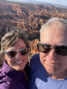
Capitol Reef Park has been hands-down the favorite of the Mighty 5 thus far for both Jim and I. It is jaw-dropping to be up close and personal amongst the towering cliffs. A wrinkle in the Earth – a vibrant palette of color spills across the landscape before you. The hues are constantly changing, altered by the play of light against the towering cliffs, massive domes, arches, bridges, and twisting canyons. Over millions of years geologic forces shaped, lifted, and folded the earth, creating this rugged, remote area known as the Waterpocket Fold.  Where did the Park get it’s name? Two features: the first being ‘Capitol Dome’, a sandstone mountain, blond in color, resembles the U.S. Capitol. And second, for the 100- mile Waterpocket Fold, which is a wrinkle that barred early travelers like a barrier reef.
* Fruita area: Apple and Cherry Pies, Yum! Capitol Reef maintains one of the largest groups of historic orchards in the National Park Service. With about 2,000 trees, fruits include apple, peach, pear, apricot, cherry and plum. Flowering typically occurs from March into May, and harvest generally occurs June through October. Fruit is free to sample while in the orchards; a small fee is charged for fruit taken out of the orchards. Although the harvest season this year was already over, we did however get to purchase some fresh-baked pies at the historic Gifford House and enjoyed them along with ice cream right beside the Fremont River. Lots of deer live here in this area and we saw many of them including spotted fawns with their moms. Pictured above is one of the sweet horses that are stabled nearby. Close to this too is the Fruita Campground which we looked into camping here, but with the temperatures being so high (in the high 90’s), we thought it best to camp at a private RV park with water and electricity to keep the AC running for Darcy.  Not only was that a good decision for that factor alone, but they had Loop B closed off due to recent mountain lion activity!
* Petroglyphs: these panels are conveniently located right off the main Hwy 24; no hiking needed to pull over and park and walk the boardwalk right up to them. Very interesting!  There are more carvings deep into the Park, but require backcountry long hikes to get to them which we did not do. 
* The 7-8 mile long Paved Scenic Drive is a narrow but stunning drive. Quite intimidating at first, with it’s many twists and blind curves, and the many ‘washes’ that the road simply dips into and goes over. I can’t imagine being out here when it’s raining and have to cross over/ drive right through the wet washes. Thankfully, the pavement was dry so no worries there. However, there are two spur roads off the Scenic Drive that are not paved and enter into Canyons. On the first day of exploration, we wimped out on taking Lois deep into these roads, as can’t miss warning signs are posted at the entrances demanding that drivers have a healthy respect for them AND the weather. The third gravel road was definitely one for us to stay away from since it requires you have a high clearance four-wheel drive vehicle.
* After speaking with a Ranger at the Visitor Center on the second day, we felt a little more comfortable to consider driving the gravel roads.  First up, the Capitol Gorge dirt road found at the very end of the pavement’s end. It’s two miles in length, and at the end of it you can get out on foot and hike an additional mile into the Canyon, which we did. However – a storm (really just an isolated rain cloud) was approaching, so it was enough to keep our eyes peeled and hearts a racing! Because this location was exactly where a Flash Flood occurred back in June that swept 10 or so cars down the wash, leaving some folks stranded to be rescued by helicopter. There’s a YouTube vid of someone’s first-hand experience with this particular Flash Flood. Watch it at the link 


https://www.youtube.com/watch?v=FJOpZF_4b-w&t=698s&ab_channel=Owensuptosomething


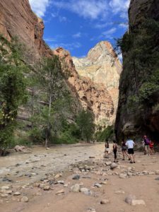
* Once the Gorge was under our belts, the rain cloud had moved onwards never really releasing any rain near us. So, up next was the second exhilarating expedition into the 1.3 mile Grand Wash dirt road and hike an additional 2 miles into the Narrows. So beautiful.

————–


Bryce Canyon NP, and
Red Canyon NF 


Stayed near Panguitch Utah to see Bryce Canyon. Actually, we were a bit closer to the Park (thankfully) by camping at Red Canyon Village RV Campground on Hwy 12 itself. Shaved off a good 20 minutes. Very close to Red Canyon by just a few miles. 
——————
Bryce Canyon National Park
Finding ourselves here at the beginning of September, the crowds had died down somewhat. Shuttle service was offered for the first portion (the Bryce Amphitheater), but we found that the traffic was light enough to take our own car in. Parking spots are very limited, so the Shuttle would definitely be the way to go in the busy season. Bristlecone Pine Loop Trail was enjoyable, located at the end of the 18 mile Park road.  Tip for Sunset: don’t go to the popular Sunset Point overlook, but rather to Fairyland Point. Although we weren’t present at either location for sunset, I can see why someone recommended this tip. We also took the time to see Mossy Cave, which was a short and fun hike – the grotto itself was dry with no waterfall, but the moss still had enough humidity to thrive. There was some water still flowing through the canal (man-made by the Mormans years ago via picks and shovels to divert water 17 miles away in Tropic UT) which had quite a large and fun waterfall.
——————
Red Canyon National Forest.   
I enjoyed this area almost more than Bryce Canyon! It was so beautiful, especially during the late afternoon and Golden Hour when the soils/rocks glowed red.  Very very scenic. We devoted one day here and could have easily spent two or three additional days exploring. There is a very nice bike trail starting here that moves westward all the way into Bryce. Lots of pretty shaded National Forest campgrounds located in this canyon too.
————-
Hwy 12 Scenic Byway ride.
This highway was so pretty, and starts at Panguitch (or more accurately, Red Canyon village where we camped) and goes all the way to Torrey Utah, home of Capitol Reef National Park). This highway is not for the faint of heart, and is NOT recommended for big RV’s. We took Lois down the road for a bit beyond Bryce, but in the coming days once hitting the road for Torrey, we had to divert Clark around and take a longer route.
————-
Hwy 143 “Patchwork Parkway National Scenic Byway” scenic ride.
If you have extra time in the area of Panguitch, then don’t miss the chance to drive this highway. Cedar Breaks National Monument was a surprise, and a fantastic treat! High elevation overlooks and cool temps (about 10 degrees cooler in the late afternoon, and I imagine 10 degrees more once the sun goes down).
————–
My birthday was here, and I of course had to indulge my Tutu Fun – twice in one day!.
————–


Horseshoe Bend

DRAFT DRAFT DRAFT  All the different days/regions we explored in Page Arizona (August 27,  28, 29, 30, 31, September 1 and 2) can be found in the Picture Album #62, link found in each paragraph below.
We arrived in Page Arizona in the late afternoon, and managed to set up camp and have enough time to jump back in the car and head to Horseshoe Bend at the perfect time: Sunset. It was beautiful. Kayakers down at the water’s edge looked so tiny! We hope to do a water trip on the Colorado River here to see the Bend from a different perspective. The Bend is shortly after the Glen Canyon Dam which holds back the reservoir of Lake Powell.

………………………………………………………………………………………………………………………………………

.

Antelope Canyon

        Antelope Canyon is on Navajo lands, so you must book a Navajo Indian Tour Guide to see this magnificent slot canyon. The interesting thing about this canyon is it’s ever-changing landscape, all shaped according to the waters that flow through here. Just two years ago, the floor of the canyon was about 20 feet higher than today! Flash floods constantly carve out new corners to peek around. The canyon has two areas, an Upper section and a lower section. We toured the Upper Canyon, which has a shape like an “A”, meaning the floor is wider than the top, allowing sunbeams to find their way in to the slot, while the Lower canyon is the exact opposite in the shape of a “V”.  The actual tour began at their office location in downtown Page, so it is there where we hopped on a  15-person shuttle van equipped with super sized cold A/C and 4-wheel drive super-sized tires. Drove about 10 miles outside of town onto a gravel road and then down into the actual wash itself! That’s when the 4-wheel drive was needed, and was so much fun in and of itself! This was obviously not the first time this Navajo driver navigated the sometimes sandy, sometimes mushy river/wash, evidenced by his one hand on the wheel and the other holding a thermos of chilled water.  The tour was not cheap, but so well worth it and I highly recommend it!

Page AZ pics (album 62)

………………………………………………………………………………………………………………………………………

West Page (Wahweap Marina, Lone Rock Beach, Glen Canyon Dam, Lake Powell Boat Ride

 * Wahweap Marina (also known as Lake Powell Resorts and Marina).  Boat ramps closed everywhere; no boats can launch anymore because the ramp’s end is now about 40 feet above the water line!
* Lone Rock Beach – this is (or was) a popular boondocking site for campers. Not so much these days due to the low water levels exposing new (and sandier) lakebed. The loose gravel and hard-to-tell dirt roads were kind of sketchy. Driving Lois down here was a bit unnerving, and I can’t imagine driving a rig down! There was one lone Boon-docker (truck and trailer rig) around, and only a few more day use folks here. Sad to see that the water has receded so far down that there is no water nowadays around the rock. YouTube videos we watched from 2020 and earlier had boats and jet-skiers driving around the rock, and boogie boards and SUPs at the water line just yards away from their campers – not so anymore sadly. 4-wheel drive is recommended.
* Glen Canyon Dam – Carl Hayden Visitor Center is located right at the dam as well as the ——— bridge.
* Lake Powell Boat Ride – 

Page AZ pics (album 62)

………………………………………………………………………………………………………………………………………………


East Page (Antelope Point Marina, town pics, scenic drives and overlooks

        Next up on our exploration of Page area was Antelope Point Marina, the newer of the two marinas in the area.
         Hikes in this area included ……… 

Page AZ pics (album 62)

………………………………………………………………………………………………………………………………………………

Zion National 

Park 


DRAFT DRAFT DRAFT – more verbiage when I can catch up. Stay Tuned!
Springdale, Utah
First visit for Utah’s “Mighty 5” National Parks.
——————
Flash Floods. Tried twice, but No hiking the Narrows.
——————
Happy Birthday Jim!
————–


Kolob Canyon section of the Park; experienced a strong storm approaching. Aborted a hike due to lightning, raced southward back to Springdale just in time to hunker down at the campsite. 

——————-


Trains, Stars, Cave Lake SP, Charcoal Ovens, Hwy 50

   Ely (pronounced “E-Lee”).


DRAFT DRAFT DRAFT – I’m falling behind but will catch up soon and fill in the blanks. Meanwhile, the pic albums (#59 and 60) have been created and posted and I didn’t want to keep you Readers waiting for new blog entries! So enjoy, and come back in a few days for more verbiage.


 * Sunset, Stars and Champagne Train Ride!  Nevada Northern Railway Astronomy Train Tour.
* Cave Lake State Park
* Charcoal Ovens
* Hwy 50 – “the loneliest road in America”.
*Railroad Depot Museum


Pictures in Ely, NV (album #59)

………………………………………………………………………………………………………………………………………

.

Great Basin National Park

          The Great Basin National Park is the least visited National Park in America.   It’s certainly not due to the many unique and interesting things to see and do here, but rather because of it’s actual location; very remote and out of the way. Yet it is only 60 miles away from Ely.
* International Dark Sky Park – Great Basin got this designation in 2016. This remote park has such clean air and very little light pollution. Its night sky offers brilliant views of planets, constellations and the Milky Way. We disappointingly could not stay in the Park too long after dark because we needed to get back to “Clark” and rest up for a Travel Day the next morning. 
* We did drive the entire Wheeler Peak Scenic Drive all the way up to the end of the road. By this time, the sun was fast setting and we were not dressed warm enough to take on the 3 mile hike (and 1200 feet elevation gain) up to view the Bristlecone Pine trees and see Wheeler Peak higher than 10,000 feet. Yet we scrambled up the trail about a 1/4 mile and scrambled back down even quicker due to the falling temperatures. Back at the Parking Lot, a distressed & crying 20-something guy from Virginia was yelling “Dakota” over and over; sadly, his hound dog had been off leash on the Wheeler Peak trail and somehow got separated from his owner, and had been missing for hours.  We can only hope that “Dakota” could smell the human scents of the nearby small campground, and hone in on that as well as realizing to remain descending from the mountain top. I don’t think the guy was going to leave the parking lot until he found him. Fortunately, some overnight campers consoled him and were helping with calls out into the woods. It was heartbreaking to know this dog/man partnership had been on the road for several weeks together and be torn apart so unexpectedly.
* Bristlecone Pines
* Lehman Caves

Great Basin NP incl Lehman Caves pics (album #60))

………………………………………………………………………………………………………………………………………